Updated at 9 p.m. This from the New York State Thruway Authority: Due to Severe winter weather conditions, at 11 p.m. the New York State Thruway will be closed between Interchange 17 (Newburgh/I-84) and the New York City line, including I-287, the Cross Westchester Expressway, and I-95, The New England Thruway. Also, all tractor trailers will be banned on I-87, both directions, between Interchange 24, Albany (I-87), and The New York City Line, including the Berkshire Connector between I-87 and I-90 in Massachusettes. The ban on long tandem tractor trailers will continue between Interchange 32 (Westmoreland), and the New York City Line, until further notice. Updates will be provided as conditions change.
____
Updated at 3:30 p.m. Eastern: Governor Andrew M. Cuomo has declared a state of emergency for the following counties ahead of the anticipated extreme winter storm: Bronx, Dutchess, Kings, Nassau, New York, Orange, Putnam, Queens, Richmond, Rockland, Suffolk, Ulster and Westchester and contiguous counties.
He also announced a tractor trailer ban will be in effect on major state highways beginning at 4 p.m.
Massachusetts has announced a completed ban on travel statewide starting at midnight.
Connecticut just announced a total travel ban starting at 9 p.m.
The New York State Thruway Authority is restricting all tractor trailers on I-87, both directions, between interchange 17 (Newburgh/I-84) and The New York City Line, including I-287, the Cross Westchester Expressway, and I-95, The New England Thruway. In addition, long tandem tractor trailers are banned between Interchange 32 (Westmoreland), and the New York City Line, Including I-287 the Cross Westchester Expressway, I-95, The New England Thruway, and I-90, The Berkshire Spur, until further notice. Updates will be provided as conditions change.
The State is considering a full travel ban on roads and bridges as well as the potential closing of public transit networks in affected areas beginning at 11 p.m.
_______
More than 3,000 airline flights have already been cancelled and municipalities in the storm’s path are marshaling their snow removal forces.

Here is what the National Weather Service’s Eastern Regional Headquarters in Bohemia, NY released at 9 a.m.:
“Light snow has started to overspread parts of the mid Atlantic and Northeast from Washington DC to New York City this morning as the storm that moved through the Ohio Valley overnight starts to redevelop off the North Carolina coast. The snow will be intermittent and generally light as the coastal storm organizes and begins to strengthen. By mid afternoon and especially during the evening, steadier and heavier snow will begin to develop and move northward up the I-95 corridor. Winds will also increase overnight, resulting in considerable blowing and drifting snow limiting visibilities to near zero. Travel will become increasingly difficult this afternoon into the evening, and will be nearly impossible overnight into Tuesday from roughly Philadelphia northeast into Maine.
“Very little has changed overnight regarding the forecast for this storm, as widespread snowfalls of 1 to 2 feet are expected, with some areas receiving 2 to as much as 3 feet. Snowfall rates of 2 to 4 inches per hour are expected tonight into Tuesday. Strong winds of 20 to 40 mph, with gusts of 40 to 60 mph are expected to result in drifts of 3 to 5 feet. Moderate coastal flooding is expected, especially during high tides, from the Delaware Bay northward. High waves and heavy surf is expected to cause considerable beach erosion, and damage is possible to exposed waterfront structures.”
_____________
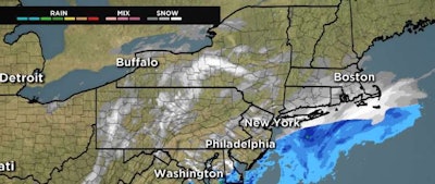
Much of the Northeast is bracing for what is being forecast as a mammoth winter storm.
The National Weather Service’s East Regional Headquarters in Bohemia, NY at about 6 p.m. Eastern issued this statement on the storm:
“Confidence is increasing on a historic winter storm across parts of the Northeast Monday night thru Tuesday night, tapering off Wednesday morning. Blizzard warnings have been issued along the Eastern Seaboard from central New Jersey north through the New York City metro area and northeast across Connecticut, Rhode Island, eastern Massachusetts, and coastal New Hampshire and Maine. Snowfall rates of 2-4 inches per hour are expected, resulting with snowfall totals of 18 to 30 inches, with locally higher amounts. In addition very heavy snow, strong winds in the Blizzard Warning area are expected to gust to 35 to 50 mph, with gusts as high as 65 mph possible across eastern Long Island and Cape Cod. The heavy snow and blowing and drifting snow will reduce visibilities to near zero, making travel extremely dangerous. Snow drifts may exceed 3-4 feet across the blizzard warning area.
“The strong northeast winds will create a storm surge along the coast. Moderate coastal flooding, especially during high tides is possible along the coast from Delaware Bay north all the way to the Maine coast. Major coastal flooding is possible along east facing sections of the Massachusetts coast. The strong winds will also create high waves that will likely result in significant beach erosion, as well as splash-over that could result in damage to waterfront structures and closures of shoreline roads.
“Some uncertainty remains regarding how far west the heavy snowfall will get. That is why there is an area of Winter Storm Watches from Delmarva north across eastern Pennsylvania to the western Catskills and north into northern Vermont. Forecast confidence across this area is less than the area of Winter Storm Warnings further east.”
Here’s what New York State is doing in anticipation of what it considers an historic storm.