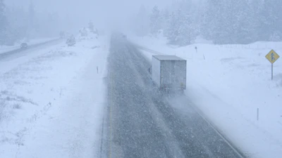
Truckers ought to be aware that severe winter weather is soon expected to create driving difficulties across many major freight routes from the Souhtwest to the Northeast.
A major, long-duration winter storm is expected to overspread as many as 35 states starting Friday and lasting through through the weekend and into Monday.
The National Weather Service's Prediction Center reports the storm will contain heavy snow and damaging freezing rain, and sleet. It's expected to affect 230 million people from New Mexico to New England. The National Weather Service said, "Widespread travel disruptions are likely."
The Weather Channel reports the storm's ice in the South could lead to "long-lasting power outages and tree damage."
At least 10 states in the Northeast are expected to receive as much as a foot of snow accompanied by high winds. States along the Great Lakes could see several feet of snow.
The Weather Channel's timeline for the storm includes:
- Friday: Snow, sleet and freezing rain will increase by late morning or early afternoon in the Plains, including parts of Kansas, Oklahoma and northern and western Texas.
- Friday night: Snow, sleet and ice will continue southward in the Southern Plains and into the Central Plains, and lower Mississippi Valley
- Saturday: The mix of snow, sleet and ice could sink farther south in Texas, Louisiana and Mississippi, and pick up in the mid-Mississippi and Ohio Valleys, Kentucky, Tennessee, West Virginia, Virginia, parts of the Carolinas and perhaps far northern Georgia.
- Saturday night: The storm may sag even farther south toward parts of southeast Texas, southwestern Louisiana, central Mississippi, northeast Georgia and South Carolina. Snow will spread into the mid-Atlantic states and intensify while continuing farther west into the Ohio Valley, mid-Mississippi Valley, Ozarks and parts of Oklahoma, Texas and New Mexico.
- Sunday: Precipitation will end in Texas, Oklahoma and the lower Mississippi Valley by midday, but will persist in the Great Lakes, Ohio Valley, piedmont region of Virginia and the Carolinas and the Northeast.
- Sunday night and Monday: Snow will continue throughout much of the Northeast, but could mix with sleet, ice or change to rain near the coast from southern New England and Long Island to the Delmarva Peninsula as a nor'easter moves along the East Coast. Snow may also linger in the Great Lakes, Ohio Valley and Appalachians. Areas of sleet and/or freezing rain may also linger in pats of Virginia and the Carolinas before either changing to rain or ending before sunrise Monday morning. Some snow is expected to linger in parts of the Northeast, especially New England, on Monday, along with gusty winds as the nor'easter gradually moves away.