Today, Louisiana Gov. Jeff Landry signed a State of Emergency Executive Order as Tropical Storm Francine approaches the Gulf Coast.
The declaration includes a temporary exemption of Federal Motor Carrier Safety hoiurs of service regulations Title 49, Part 395.3 and 395.5 for motor carriers providing direct assistance to disaster relief efforts in the state. This relief includes, but is not limited to, power grid repairs, storm debris removal, delivery of groceries, fuel, propane, and other essential products.The emergency declaration took effect at 12:01 a.m., today, Sept. 10, and will remain in effect for the duration of the emergency or until 11:59 p.m., Sept. 23, 2024, whichever is less.
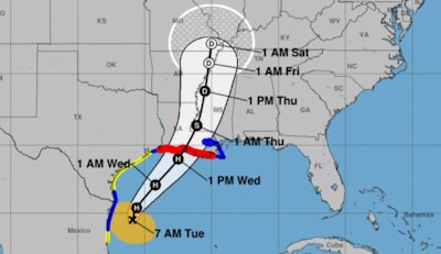
Life-threatening storm surge and hurricane-force winds, as well as the risk of considerable flash flooding are forecast across southern Louisiana on Wednesday as Francine approaches, according to the National Weather Service. As of early this morning Tropical Storm Francine continues churning in the western Gulf of Mexico just to the southeast of Brownsville, Texas and moving on a gradual northward motion. Francine is forecast to strengthen into a hurricane before an expected landfall in southern Louisiana on Wednesday.
The Weathe Channel has reported the track for Francine has shifted eastward with alerts now issued for the Mississippi and Alabama coasts.
The weather service today said, as the system approaches the central Gulf Coast and eventually pushes inland across Louisiana, an increased threat of life-threatening storm surge, hurricane-fore winds, and considerable flash flooding is anticipated. Rainfall amounts of 4 to 8 inches, with local amounts up to 12 inches are forecast across much of central/eastern Louisiana and Mississippi through Thursday night.
According to the weather service, Francine is then forecast to continue its trek northward into the Mid-South on Thursday, while quickly weakening. However, additional heavy rainfall and flash flooding concerns are possible into western Tennessee neighboring regions. A stationary front extending eastward from the center of the storm over the next few days will also focus areas of numerous, slow-moving thunderstorms capable of containing intense rainfall rates between the Florida Peninsula and central Gulf Coast.


