Fleetworthy today announced the launch of Drivewyze’s Safety+, which offers drivers and fleets map visualization across various safety fronts.
“Our new Map View for Safety+ gives an instant snapshot as to what’s happening in a variety of risk areas, so decisions and risk-management coaching can take place immediately," said Martin Murtland, VP of Product at Fleetworthy.
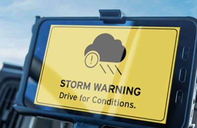
Through Safety+, drivers receive proactive location-based in-cab safety alerts about potential safety risks ahead. Alerts include:
severe weather
high-citation speeding zones
cargo theft hotspots
high-rollover areas
low bridges
state-sponsored sudden slowdowns
Safety+ also allows fleets to create their own geo-fenced custom zones to highlight safety hotspots, reinforce policies such as terminal reminders, and warn about predatory parking locations, helping reduce costs and improve driver awareness.
Safety+ Site Visits Map View transforms how fleets monitor and respond to risk by plotting safety events on an interactive map in the Drivewyze Hub portal. “Fleets can filter safety events by type, severity, date range, and more to focus on specific concerns,” said Murtland.
For example, by overlaying severe National Weather Service (NWS) alerts with the location of a fleet’s trucks and Safety+ data, managers can gain an integrated view of operating conditions without needing to switch between multiple sources and platforms. Managers can immediately see which drivers are in affected zones and take action to minimize exposure and delays.
“Fleet managers can then visually see which trucks are encountering or will encounter bad conditions, such as heavy snow, icy conditions, or local flooding, and act on it in a timely fashion,” said Murtland. “Drivers are alerted to these approaching risks to keep them safer."
Through Site Visit Map View, safety managers can also quickly identify which drivers require additional coaching and in what areas.