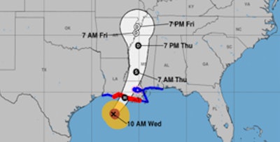
Hurricane Francine is forecast to make landfall in Louisiana this evening with damaging winds, life-threatening storm surge, and torrential rainfall before spreading impacts north to the Mid-South through the end of the week.
Once the storm pushes onshore along south-central Louisiana tonight, life-threatening weather conditions are expected to impact parts of the state, including the cites of Lafayette, Baton Rouge, and New Orleans. Hazardous weather conditions include storm surge, strong winds, torrential rainfall, and a few tornadoes.
The National Weather Service warns of:
- Some roads impassable from large debris, and more within urban or heavily wooded places
- Several bridges, causeways, and access routes impassable
- Large areas with power and communications outages
- Locations may be uninhabitable for weeks
- Considerable roof damage to sturdy buildings, with some having window, door, and garage door failures leading to structural damage
- Mobile homes severely damaged, with some destroyed
- Damage accentuated by airborne projectiles.
- Many large trees snapped or uprooted along with fences and roadway signs blown over
RELATED NEWS: Louisiana emergency waives hours of service regs as Francine approaches
While the strongest winds and peak storm surge are expected to occur closer to the center of Francine in south-central portions of Louisiana, the heavy rain and tornado threats are forecast to span much farther east along the central and eastern Gulf Coast, including southern Mississippi, Alabama, and the Florida Panhandle.
In total, Francine is expected to produce rainfall amounts of 4 to 8 inches, with local amounts to 12 inches for the central/eastern Gulf Coast through Thursday night. This rainfall could lead to considerable flash and urban flooding.
As Francine pushes northward into the Mid-South and weakens by the end of the week, additional heavy rain is possible and could lead to scattered instances of flash flooding. Additionally, a lingering frontal boundary draped across the Florida Peninsula could lead to localized flash flooding concerns over the next few days.
Residents under hurricane-related warnings should follow advice of local officials, including evacuation orders, and never drive across flooded roadways.
 National Weather Service


