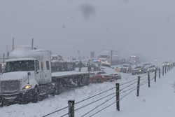
Another winter storm is shaping up to cause significant travel problems for truckers along the Interstate 95 corridor and across much of the Northeast.
According to the National Weather Service:
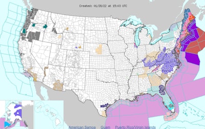
"A powerful Nor'easter is expected to develop off the Mid-Atlantic coastline on Friday before impacting eastern parts of the Northeast and New England this weekend. Numerous hazards are likely from heavy snow, with significant accumulations across eastern Long Island/New England, to gusty winds and coastal issues. In fact, the combination of snow and winds may result in blizzard conditions.
"Blizzard conditions are forecast from eastern Long Island through much of coastal New England, particularly from southeast Maine to Cape Cod. This will make travel nearly impossible."
The storm is forming off the southern Atlantic Coast and is expected to move northward, causing the worst of the weather in New York and New England starting tonight and into Saturday.
The weather service adds, "Winter Weather Advisories and Warnings are in effect for parts of the Central/Southern Appalachians. The heaviest snowfall is likely to fall across a swath extending from the Eastern Shore of Maryland up through most of Maine where 6-12 inches are likely. Parts of coastal New England, where blizzard conditions are forecast, may see between 1-2 feet of snow with locally higher amounts possible, specifically over coastal Massachusetts."
Bitter cold air will filter in behind the Nor'easter and cause temperatures to drop significantly across the eastern third of the country on Saturday. Highs will be 15-25 degrees below average in most places.
Elsewhere, an Alberta clipper system will bring light snow to the Upper Great Lakes on Saturday night while a new system emerges to produce light rain and snow over the Pacific Northwest, according to the weather service.